1/29/25 Forecast
The pattern change we’ve all been waiting for is coming this weekend. Hopefully it will materialize unlike the other “for-sure” pattern changes we’ve heard about this winter.

Taken January 29th on the top floor of the Dean. A clear and peaceful sunset.
Wednesday-Thursday Night

500mb map depicting a ridge over the Northwest U.S. and a cutoff low near the Four Corners.
Our system from last weekend is still spinning near the Four Corners. A ridge overhead will give the Reno-Sparks a winter safe haven for clear conditions for at least the next 36 hours. Low temperatures into tomorrow morning will be around the mid 20s, so still cold.

NWS NDFD’s forecast for Thursday'’s high temperatures
High temperatures will be in the mid 50s Thursday. Winds will still be light and variable throughout the day as some clouds form overhead by Thursday evening. Take Thursday to be the last uneventful day in Reno weather for at least until the weekend is over.
Friday
The 500map below will look significantly different as our pattern finally shifts to a more progressive one, leading storms to make their way into the Reno-Tahoe region.

500mb map showing a low pressure system creeping in from the Northwest U.S.
The synoptic setup over the Eastern Pacific and Western U.S. is one that promotes atmospheric rivers to make their way to our area. A low pressure in the northwest and a ridge to our south puts the Sierras in the bullseye.
This atmospheric river is more easily seen when using a precipitable water overlay. These rivers transport moisture from the subtropics to our area. This results in these storms being warmer than normal as well as bringing higher rates of precipitation.
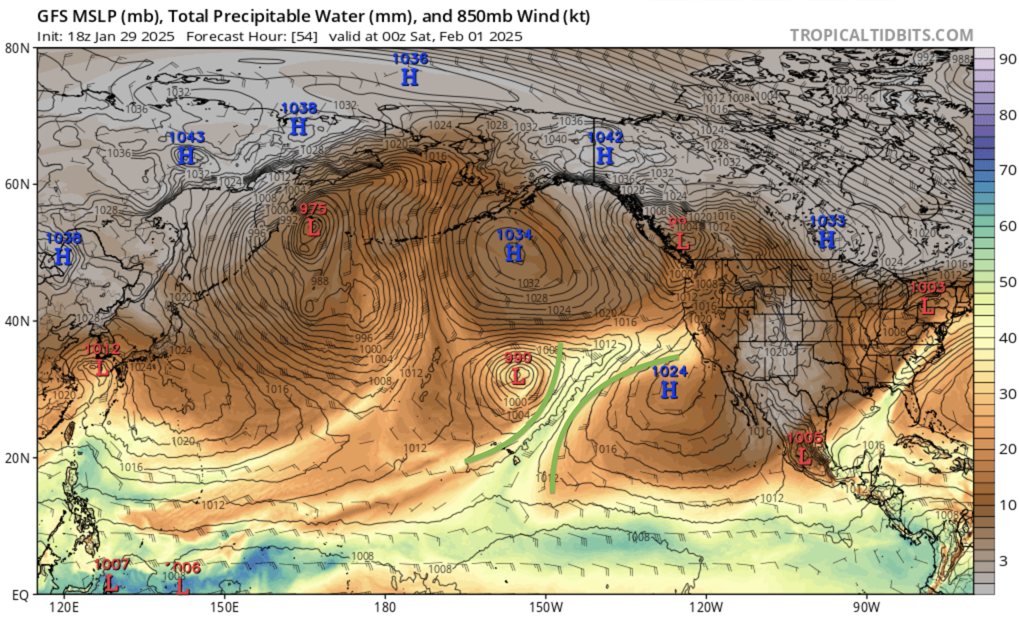
This wide shot of the Pacific on Friday shows the AR being highlighted in green.
On Friday, we will wake up to much more cloud cover as the storm nears the West Coast of the U.S. The Sierras will receive snow during Friday morning and into the afternoon as snow levels stay low during the first couple hours of this storm. Snow accumulations above 7000ft could near a half a foot before snow levels drop. Here in Reno, the foothills could receive up to a tenth of an inch of rain by midnight while the valley is likely to stay dry (outside a couple of drops that blow over the mountain)
Above is a precipitation forecast for the region from Friday morning to midnight Friday. High temperatures stay relatively warm with this tropical moisture coming in, bumping up to the mid 50s.
Saturday and Beyond
As the weekend begins, our atmospheric river continues to stay pointed at our region. Computer models are still resolving how this plume of moisture will move throughout the weekend. The GFS has the AR stalling over Tahoe through Wednesday (!!). The Euro has the AR shifting up north Monday before crashing back south Wednesday. When in doubt, look at what trends the ensemble forecasts are showing. Currently, it seems that the GFS scenario (15+ inches of QPF for the Sierra, 2-3 inches of rain for Reno) is a bit too intense while the Euro (8+ inches of QPF for the Sierra, 0.5-1 inches of rain for Reno) is a bit too dry.

The EPS ensemble average for 24-hour precipitation for Reno
Before, it looked liked like we would have two distinct storms between Feb. 1-3 and Feb. 5-7. Now, it looks like we’ll have two storms, but between Feb. 1 and Feb. 5. The signal for a more intense storm is also higher for our region. However, the bad news with this storm is that it’ll likely be all rain for the Reno-Sparks area throughout the entire duration of the sequence. Only after Feb. 5th does it look like snow levels will drop low enough for the valley to receive any meaningful snow.

The WRF’s probabilities for precipitation in Reno throughout the next week
Above is a newer model, the West-WRF, and its probabilities for precipitation in Reno for the next week. This model run was ran before models went haywire on precipitation chances went haywire this morning, so these chances are likely conservative. According to the West-WRF, there’s a 50/50 chance for more than a tenth of an inch of rain and a 25% shot for more than a half of an inch. I believe these chances to be double as of now, with about a 50/50 shot of a half inch and a 25% chance of receiving more than an inch of rain.
Saturday morning is when meaningful rain should begin to fall within the valley of Reno-Sparks continuing on and off into the early week.

OpenSnow’s forecast map for snow from now until next Wednesday
If snow levels don’t go too high, there’s a realistic chance of multiple feet of snow for the ski resorts by this time next week.
More updates will be posted as we get closer to this event…
Key Messages
Enjoy Thursday as the last day of nice weather with clear, calm conditions.
Beginning Friday morning, an atmospheric river will bring precipitation that will begin to impact the Sierras with impacts for Reno beginning Saturday morning
Significant snowfall for the Sierras is possible by this time next week and drenching rain is possible for Reno between Saturday and Tuesday. Computer models will still have to resolve differences on how intense this precipitation will be.